Monday, May 30, 2011

Larch Mountain 05/29/2011


Rex took us up to Larch Mountain via Multnomah Falls. Sunday was supposed to be the nicest day of the week of a wet May. But when we got to the top we were socked in by clouds. Here's the summit of Larch Mountain at 4,056 feet.


Self portrait of me at the summit.


Larch Mountain is a shield volcano of Boring Lavas like those found in Hawaii.


Here's the same head piece of rock on Larch Mountain summit that I scaned from We Climb High: A Chronology of the Mazamas 1894-1964 by John D. Scott.

Sunday Parkways


This weekend set off the first of our Portland Sunday Parkways at East Portland. My mother and I didn't ride up their but we volunteered as Intersection Superheros. It was cloudy, but no rain.


Nesmith Point 05/14/2011


The lookout from Nesmith Point at 3872 feet elevation. With BCEP over we got a few classmates together for this conditioning hike.


Here is as survey marker.


Andrew, Patrick, and Karen

Oregon Zoo 05/10/2011


The second Tuesday of each month the Oregon Zoo offers a reduced admission. The weather looked nice enough to go. Here is a Mazama.


There was a Polar Bear with a toy.


This baby elephant is scratching his back side.

BCEP Graudution


Here is my Basic Climbing Education Program certificate of completion.

Mt. Defiance 05/01/2011


Here's me on the summit with Mt. Hood in the background. Mt. Defiance is a good training hike for Mt. Hood. It is near the same elevation gain from Timberline. There was snow, we had it from about 3,500. And it is steep!


Mount Hood north side was taking from Mt. Defiance summit


Here is the Group 20 BCEP photo on top of Mt. Defiance. The group was in the wilderness area so it was limited to 12. Bruce and two of our students didn't go. Dan and Sue led this hike.

Horse Theif Butte 04/23/2011


Roger, Patrick, and me watching the leaders set up the climbing routes.


Doug, Elena, and me getting ready to rappel.  I had some problem with rappelling on this day, I had trouble weighting the anchor on my pro.   It took me half the day to complete my first rappel, but after that I did like a total of like 3 or 4.


Snow Day on Mount Hood 04/16/2010


We moved the now day from Timberline Lodge to White River because of rain.  We got wet, but leaned a lot about snow travel.  Here I am learning to glissade, my ice ax is my brake as I slide down the snow hill.


MMC Climbing Wall 04/10/2011


Tieing in to the rope.


Belay is on!


 Climbing at the MMC.

Table Mountain 04/09/2011


Bunny ears is a rock formation at the base of Table Mountain.  I would like to climb it someday.


John Park near the summit of Table Mountain.


The views from Table Mountain were a lot the hikes of BCEP with clouds covering most of the sky.

Archer Mountain 03/30/2011


Here's are some neat rock about a mile off of the ridge, they are called Pancake Rocks.


Hamiltion Mountain 03/26/2011


We had our first BCEP hike to Hamilton Mountain, near Beacon Rock on the Washington side of the Columbia River Gorge. It was a very wet hike and this is a group photo on the way out. We packed about 20-25 lbs. of weight in our packs for training.


Here is Rodney falls on the way up to Hamilton Mountain. We had good view of water features, but do to the weather the lookouts were somewhat compromised.


This is the Pools of Winds. As you enter it, there is a large waterfalls noise that is amplified naturally.


Here's are some rocks on the way up to the top.


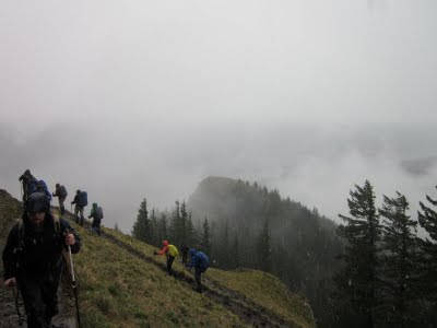
The hike up to the summit, the clouds were low enough that we couldn't see Mt. Hood.


Karen at the summit of Hamilton Mountain elevation 2480 feet.